Arthur disrupts holiday plans
Published 7:52 am Thursday, July 3, 2014
The first hurricane of 2014 is making a beeline for the North Carolina coast.
Hopefully, Arthur will remain on its predicted path, a jaunt to the northeast, which will soften the impact along the North Carolina coast as well as the inland counties.
As of late Wednesday afternoon, each of the Emergency Management directors in the Roanoke-Chowan area say that the local impact in Bertie, Gates, Hertford and Northampton counties will be minimal….if the center of the hurricane remains offshore as predicted.
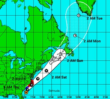
This map represents the 5 a.m. Thursday update provided by the National Weather Service relating to what was then Tropical Storm Arthur. The storm reached hurricane strength today (Thursday). The Hurricane Warning areas are shown in red, with the Tropical Storm Warning areas in blue. Map courtesy of NOAA
The timing of the storm for the R-C area may fall anywhere between late Thursday afternoon until midnight. Arthur is expected to gain forward speed Thursday night/Friday morning. Improving conditions will be noted later in the day on Friday, perhaps clearing totally by Friday night….just in time for the fireworks in Ahoskie and Jackson which are both still scheduled at this time.
Bertie may see the most significant rainfall and wind, basically due to its proximity (the eastern edge touches the Albemarle Sound). The National Weather Service put the western Albemarle Sound, which would include that area of Bertie County, under a Tropical Storm Warning as of 5 p.m. Wednesday.
“We expect it to impact us around midnight on Thursday,” said Bertie Emergency Management Director Mitch Cooper. “Based on the strength of the storm, we’re looking at 2-to-3 inches of rain and 55 mph winds.
“We do not anticipate major hazards,” Cooper added. There will be some minor flooding, but we do not expect any long-term flood effects. There may be some flash-flooding in low-lying areas; and with the winds there could be some downed trees and power lines. Again, for now we’re just monitoring and we don’t anticipate any long-term effects (from the storm).”
Hertford County Emergency Management Director Chris Smith said the Thursday/Friday forecast calls for 1-to-2 inches of rain and 15-to-25 mph winds, with gusts as high as Tropical Storm force (in excess of 39 mph).
“This is one of those situations where the severity of the amount of rain and wind is based on the timing of a storm taking a more easterly movement out over the ocean,” Smith said. “As of right now (6 p.m. Wednesday), we’re expecting the storm to cause minimal effects here, but you never let your guard down until it’s gone. The only thing I would ask our citizens to be on guard for is minor flooding in the typical low-lying areas of the county as well as downed trees if the winds do reach any higher than Tropical Storm force.”
Smith said he doesn’t think that opening storm shelters will be necessary for Hertford County residents.
“We are on standby as a shelter county for any evacuees from Dare County in case they announce a mandatory evacuation there,” Smith noted.
Gates County Emergency Management Director Billy Winn said they had also received notification to possibly serve as a host for evacuees from the coast.
“It’s just a preliminary discussion at this point,” said Winn of his Wednesday contact with state EM officials. “I do not anticipate that we will have to open our high school for that purpose, but we’ve been alerted to that possibility.’
Winn said the weather forecast for Gates County calls for up to two inches of rain and 30 mph winds.
“The farmers here most definitely need the rain…hopefully we will not have a lot of wind to go along with that rain,” he noted. “What affects we have from Arthur will be minimal.”
As the furthest inland county in the R-C area, Northampton County should see the least impact from Arthur.
“For now, our area just expects to get rain-showers and a little wind,” said Ronnie Storey, Northampton’s Emergency Management Director. “We are still encouraging people to take precautions.
“We have good drainage because of the soil here in our county, so any spotty flooding should subside within a few hours,” Storey added. “Our lowest lying areas are Severn and Rich Square and even there we only expect low-level flooding. My best advice is to double-check your generators and, as we like to say, ‘expect the best, but prepare for the worst’.”
Northampton County Emergency Services will be meeting at 10 a.m. Thursday at the Emergency Operations Center in Jackson to make further plans as necessary.
As far as coastal North Carolina is concerned, the National Weather Service issued a Hurricane Warning from Surf City northward to Duck (Dare County). That warning includes the Pamlico Sound and eastern Albemarle Sound. A warning means that hurricane conditions (winds in excess of 74 mph) are expected.
As of 5 p.m. on Wednesday, Arthur was moving north at 7 mph. It was expected to reach hurricane strength by early Thursday morning, at which time a turn to the northeast is expected. It may pass directly over Cape Hatteras or slightly to the east. Either way, that area will be hit by the top winds and heaviest rain.
Tropical Storm force winds (39 mph-plus) extend outward 85 miles from its center.
Storm surge of 2-to-4 feet is expected along the Outer Banks ocean front as well as the Pamlico and Albemarle sounds. Little to no surge is expected along the Chowan River.
Rainfall along the Outer Banks is expected to be 2-to-4 inches, with up to 6 inches in isolated areas.
With large swells in the ocean, rip currents will exist along the coast.
Conditions along the coast as well as the inland counties (to include the R-C area) will improve quickly by mid afternoon on Friday. The forecast calls for clear skies Friday night with a low around 67 degrees. Saturday and Sunday will be mostly sunny with highs in the mid 80’s.