Iasias bears watching
Published 6:25 pm Friday, July 31, 2020
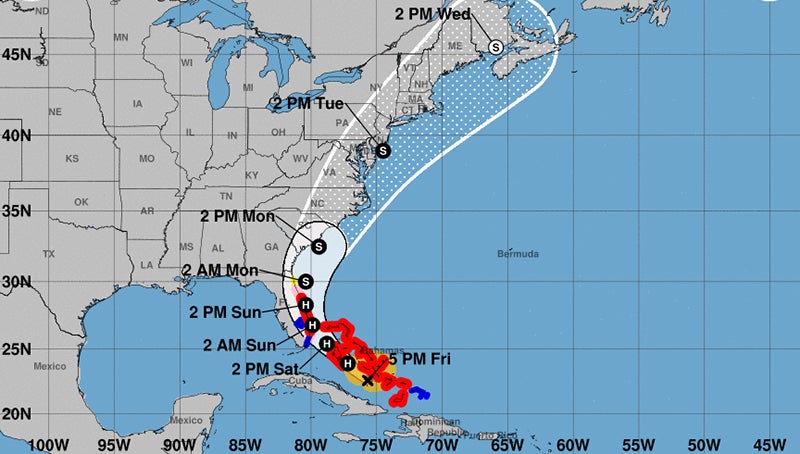
- This map, courtesy of the National Weather Service, shows the position of Hurricane Iasias as of 5 p.m. on July 31 and its expected trek up the east coast.
|
Getting your Trinity Audio player ready...
|
The hurricane with the hard-to-pronounce name may be even harder to predict exactly where it make landfall along the east coast.
As of late Friday afternoon, Hurricane Iasias (pronounced ees-ah-EE-ahs) had moved into the Central Bahamas where it was showing some signs of becoming better organized. The top wind speed at that time was 75 mph.
While the storm was hundreds of miles away from the Roanoke-Chowan area, local residents need to keep an eye on its path.
Officials with the National Weather Service expect the storm to make a gradual turn to the north-northwest. It will encounter a shortwave trough digging into the southeastern United States. The timing and strength of this trough will determine how far west Isaias moves before the hurricane
turns northward. The further west it tracks will determine if it makes landfall over North Carolina’s southeastern coast sometimes on Monday.
Local emergency management directors are reminding R-C area residents that just a slight shift in the storm’s track will have a significant impact on the weather conditions in the northeastern corner of the state.
If the hurricane remains on its current track, expect tropical storm force winds (20-to-40 mph) locally. Those winds could be higher (40-to-60 mph) along the Albemarle Sound.
“As of now our area is predicted to possibly see winds at or below tropical storm force and rainfall amounts around two inches. We are very dry so rainfall should not create any issues,” said Chris Smith, Hertford County’s Emergency Management Director.
Along the immediate coast, Hyde County officials wasted little time in enacting precautionary measures. On Friday morning, the county commissioners there issued a state of emergency and a mandatory evacuation of Ocracoke Island. That evacuation was scheduled to begin at 8 a.m. Saturday.
Dare County Emergency Management advised residents and visitors on Friday to begin implementing their hurricane preparedness plans. Local officials will confer on Saturday morning to determine whether protective measures are necessary to ensure public safety.
Based on the current forecast, visitors scheduled to travel to the Outer Banks this weekend are advised to closely watch updated information from the National Weather Service Center and consider delaying arrival until after the storm has passed.
“Dare County is likely to experience impacts from the storm as early as Sunday evening, August 2,” said Dare County Emergency Management Director Drew Pearson.
Should an evacuation order become necessary, it will be important to allow extra time to evacuate. In light of COVID-19 and with social distancing measures in place, state sheltering options will be limited. As always, you are better off locating shelter with family or friends outside the expected danger zone or stay at an accommodation of your choice.
Over the next few days, rough seas and strong rip currents will create dangerous conditions for beachgoers that will continue through next week. Even the most experienced swimmers should exercise caution to ensure their personal safety. For local beach conditions, visit www.weather.gov/beach/mhx.
In preparation for the storm, Governor Roy Cooper declared a state of emergency on Friday to issue transportation waivers to allow trucks and supplies to move to where help is needed. The state Emergency Operations Center – already activated for COVID-19 – has activated for the storm as well, and state and local response teams are at the ready.
“Although the track and arrival of the hurricane could still change, now is the time for North Carolinians to prepare,” said Cooper. “Hurricane preparations will be different given the COVID-19 pandemic, and families need to keep that in mind as they get ready.”
About Cal Bryant
Cal Bryant, a 40-year veteran of the newspaper industry, serves as the Editor at Roanoke-Chowan Publications, publishers of the Roanoke-Chowan News-Herald, Gates County Index, and Front Porch Living magazine.
 More by Cal
