Old Man Winter leaves ‘gift’ of white
Published 3:55 pm Wednesday, February 25, 2015
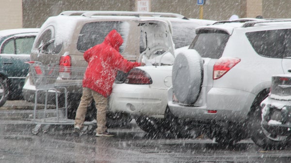
A local resident loads groceries into their vehicle in the parking lot of the Ahoskie Piggly Wiggly as snow falls on Tuesday afternoon. Local grocery stores were packed again on Wednesday as area residents were prepping for a larger snowstorm expected to arrive Wednesday night and last well into Thursday morning. Staff Photo by Cal Bryant
Local stores were packed on Wednesday, almost to the point where one would think of the brisk business always witnessed on Christmas Eve.
However, Santa Claus didn’t make a late visit Wednesday night into Thursday. Old Man Winter took his place.
With the forecast calling for as much as 10 inches of snow, Roanoke-Chowan area citizens were busy on Wednesday preparing for one of the biggest snowfalls since the Christmas 2011 storm.
The forecast models were inconsistent on Tuesday into Wednesday morning….some predicting 3-to-5 inches; others saying 4-7 inches; and one with a “sweet spot” directly across the R-C area and saying there is a possibility of 8-10 inches of the white stuff.
“Four inches will cripple us; so double that and we’re in for a doozie of a winter storm,” Northampton County Emergency Management Director Ronnie Storey Jr. said Wednesday morning. “We were originally told to expect 4-to-7 inches of snow; then that changed to 8-to-10 inches. All I can tell you is that we will see a significant amount of snow from this system.”
Storey said that with Wednesday’s temperatures warming into the mid 40’s and with lots of sunshine, that allowed plenty of melting to occur from Tuesday’s snowfall (roughly 2-to-3 inches fell from that storm locally).
“I’m thinking that this bigger storm may start as rain Wednesday evening because the temperature will still be well above freezing at that time,” he said. “But as the temperature falls, I’m expecting the rain to change over to all snow well before midnight. The brunt of the heavy snow will fall between 10 p.m. and 4 a.m. This system is coming from the southwest, and from the weather model I looked at the heart of the storm will pass directly through our area and then into Virginia.”
Storey urged all local residents to stay at home.
“If you do have to venture out on the roads Wednesday night and into the day on Thursday, take it slow and easy, with no sudden stops to prevent your vehicle from going into a skid, which could land you in a ditch or worse,” he said. “And be reminded that if you do call for help, whether it’s due to a wreck or you need EMT’s due to a medical emergency, be reminded that our response will be hampered by the road conditions.”
In Bertie County, officials first had to deal with sheet metal carnage in the aftermath of Tuesday’s snowfall before they could start preparing for the next round of winter weather.
“So far between Emergency Services, the Bertie County Sheriff’s Office, and the Highway Patrol, we’ve responded to 35 accidents, but there haven’t been any other non-vehicle concerns that were weather-related,” said Bertie Emergency Management Director Mitch Cooper on Wednesday. “Now we can start prepping for the next storm.”
Again, the winter weather forecast models were not in agreement on Wednesday as to how much snowfall Bertie County residents could expect.
“We’ll hold out last briefing this afternoon (Wednesday) around 4 p.m. and make our final plans; our staff is getting set in the meantime,” Cooper said. “Right now there’s still a lot of uncertainty; we’ve been told we could get anywhere from 4 inches to 12 inches of precipitation, so our trucks are ready for whatever comes down.”
The National Weather Service office in Wakefield, VA has placed northeastern North Carolina and southside Virginia under a Winter Storm Warning from 7 p.m. Wednesday until 1 p.m. Thursday. For the Roanoke-Chowan area, the NWS is forecasting between five and nine inches of snow, which may transition over to a mix of sleet and snow Thursday morning before coming to an end.
Thursday’s high temp is expected to be in the mid 30’s with an overnight low of 20….meaning whatever melting does occur during the daylight hours will quickly freeze overnight; making travel extremely dangerous Friday morning.
The extended forecast calls for partly sunny skies Friday with a high of 36 degrees and an overnight low in the upper teens. Highs on Saturday will be in the upper 30’s under partly sunny skies. Temps will warm into the low 50’s by Sunday.
(Roanoke-Chowan News-Herald Staff Writer Gene Motley contributed to this story.)
About Cal Bryant
Cal Bryant, a 40-year veteran of the newspaper industry, serves as the Editor at Roanoke-Chowan Publications, publishers of the Roanoke-Chowan News-Herald, Gates County Index, and Front Porch Living magazine.
 More by Cal


